Activities in Egypt Archaeological Sites

Things to Do

Bahariya Oasis Egypt

Gebel El Dist Bahariya

  • Gebel El Dist Bahariya Oasis
  • Gebel El Dist Bahariya Oasis
  • Gebel El Dist Bahariya Oasis
  • Gebel El Dist Bahariya Oasis
  • Gebel El Dist Bahariya Oasis
  • Gebel El Dist Bahariya Oasis

Gebel El Dist Bahariya Oasis tours, booking, prices, reviews

Gebel El Dist or El Dist Mountain located in Bahariya Oasis in Western Desert, Egypt. In fact, Gebel El Dist is has an impressive pyramid shape. The mountain has symmetrical sides and pointed peak. That is why it called the Pyramid Mountain. The mountain is visible from most of the oasis. Moreover, the mountain is 100 meter away from Gebel Maghrafa and 17 kilometer away from the town. Furthermore, the mountain features a local landmark and famous for its fossils. In fact, dinosaur bones found here in the early 20th century. It disproved the previous theory which says that dinosaurs only lived in North America.

Further details about Gebel El Dist Bahariya Oasis:

Moreover, some remains of a giant specimen of paralititan stromeri found in the mountain. In fact, it was by researchers from the University of Pennsylvania in 2001. The discovery of this huge herbivore stood on the edge of a tidal channel when it died. In fact, it was 94 million years ago. Moreover, it makes likely that Bahariya oasis was once a swamp like to the Florida Everglades in the US. The mountain indeed is a challenging 1-hour climb to the top. If you did it, you will have impressive views of the oasis, desert and thousands of palm trees.

Nearby attractions Information, tours and Online Booking

More of Egypt Deserts and Oases

More of Egypt’s attractions

MORE
Gabal El Uweinat and Karkur Talh

Gabal El Uweinat Karkur Talh

  • Gabal El Uweinat Karkur Talh
  • Gabal El Uweinat Karkur Talh
  • Gabal El Uweinat Karkur Talh
  • Gabal El Uweinat Karkur Talh
  • Gabal El Uweinat Karkur Talh
  • Gabal El Uweinat Karkur Talh

Gabal El Uweinat and Karkur Talh tours, prices, booking

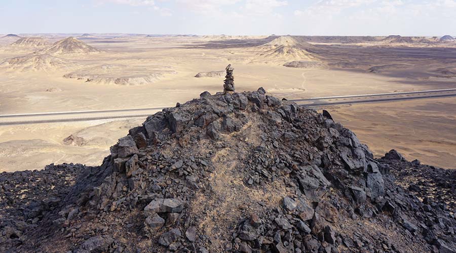
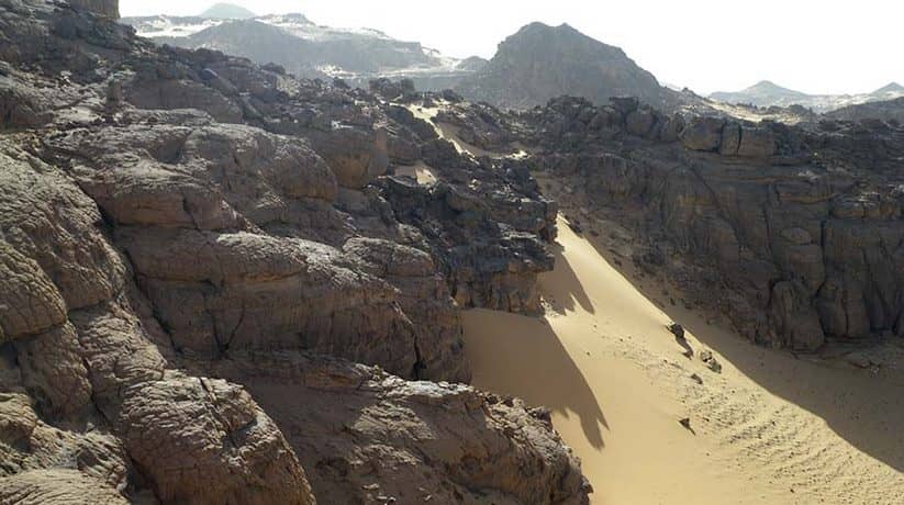
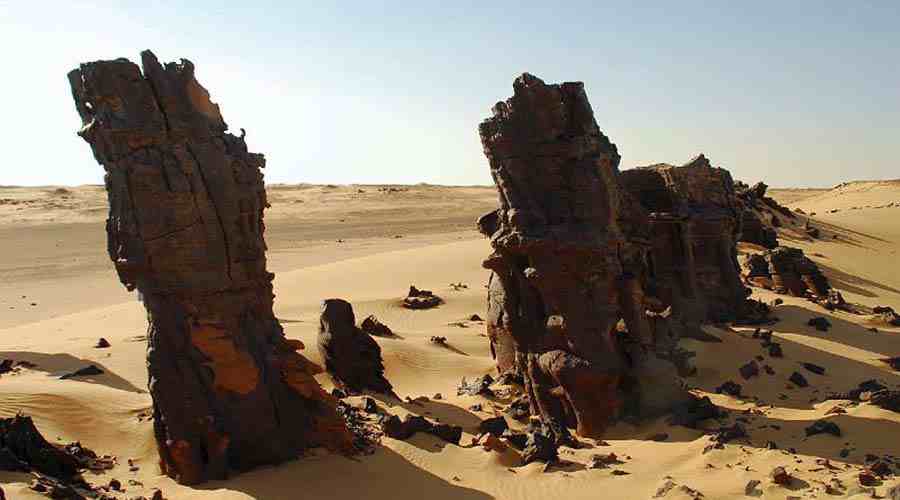
Gabal El Uweinat (El Uweinat mountain) is the most formidable mountain in Western Desert. In fact, Karkur Talh is the largest valley of the mountain. It’s mouth, marked by two acacias visible for many kilometers. Gabal El Uweinat situated in the flat and featureless Libyan Desert. Moreover, it situated roughly at the center of the arid-est area. In fact, the mountain stands out like an island from the surrounding plain. The mountain’s height is enough to capture a little precipitation. The precipitation is from the summer monsoon clouds of the Sahel belt. In fact, the belt reaches this far north. In fact, the rains here are infrequent.

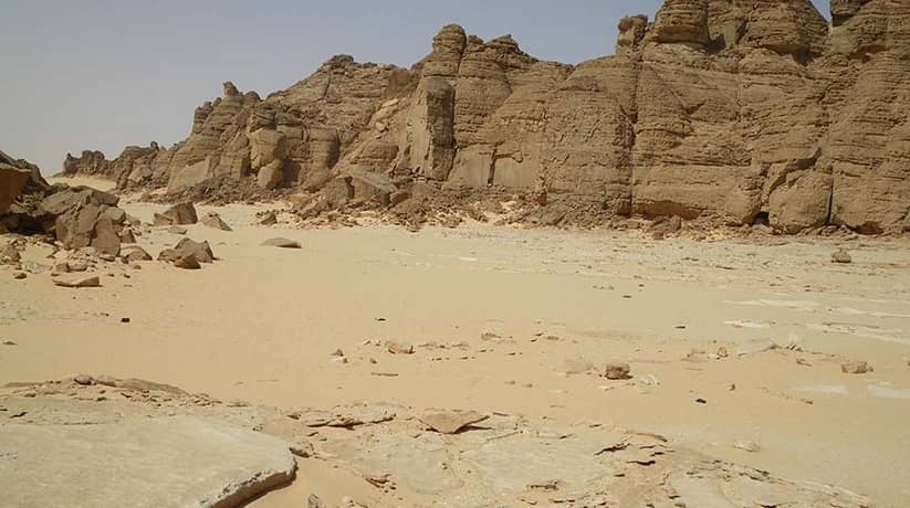
Furthermore, the last one recorded in September 1998. Probably as much as 10-15 years may pass without rain. However, even this little rain is enough for some vegetation and wildlife. In fact, Gabal El Uweinat composed of two different parts. The western part lies entirely in Libya. It composed on a large granite ring complex which about 25 km in diameter. Furthermore it also composed of the eroded remnants of a large archaic granite dome. The interior is less resistant to erosion, so large basin occupies the center of the ring. In fact, it is with three large valleys, Karkur Hamid, Karkur Idriss and Karkur Ibrahim. They drain the interior towards the west and all support scarce vegetation.

Further details about Gabal El Uweinat Karkur Talh:

As granite erodes, it forms huge boulders, that stacked upon each other. In fact, it is like an emptied bag of potatoes. Moreover, the southern half is less eroded and it has a large crescent shaped plateau. It fills the interior of the ring and much dissected by shallow water courses. This plateau acts as a large reservoir after rains. In fact, two permanent springs, Ain Ghazal and Ain Doua found at the southern foot of the mountain. Since the base of the mountain is well above the permanent aquifer. So, the source of the water can only be rain. However they never went dry in living memory.

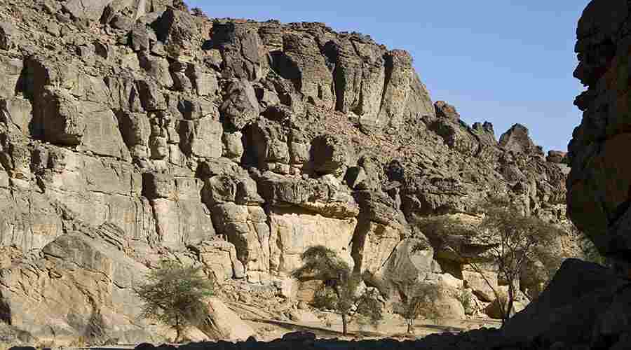
The eastern part consists of a large block of Paleozoic sandstone. The sandstone slab forms a large elevated plateau. In fact, it dissected into several large units. Karkur Talh is the largest valley of Gabal El Uweinat. It’s mouth opens onto the broad sand plain flanking the mountain on the north east side. In fact, the narrow mouth choked with sand dunes. Karkur Talh winds for some 25 km towards the base of the sandstone plateau. In fact, it forms the highest part of Gabal El Uweinat. Except for a few kilometers in the beginning, most of karkur Talh lies within Sudan.

More details about Gabal El Uweinat Karkur Talh:

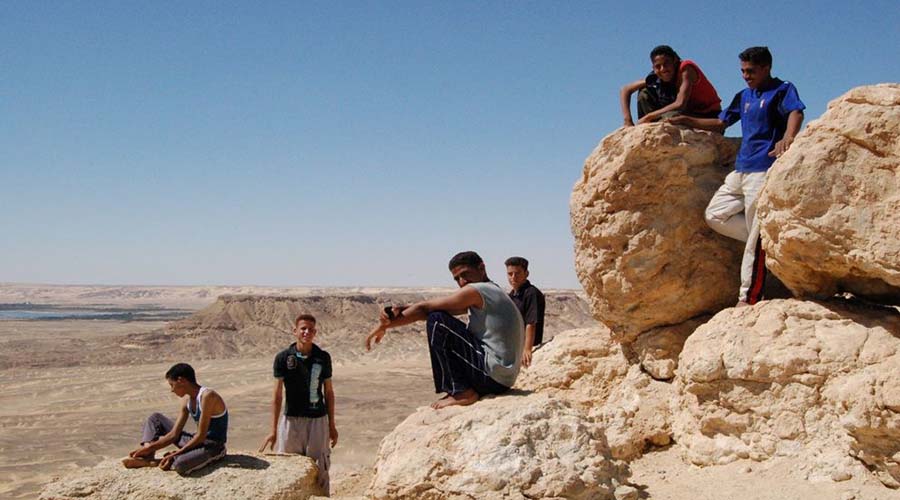
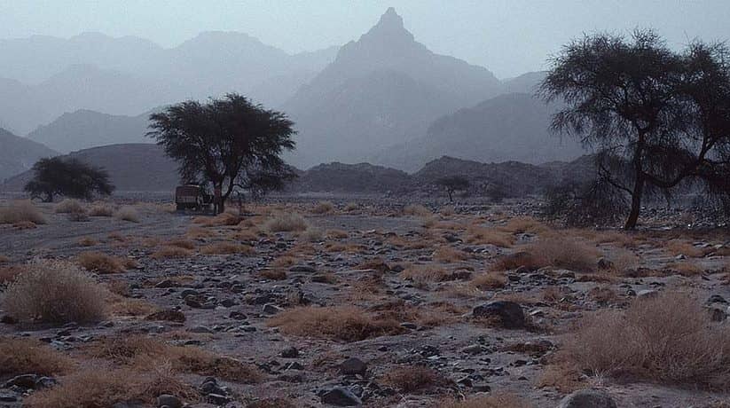
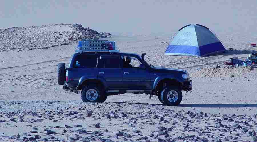
If you proceed inwards, the spaced vegetation become more frequent. It is with a dense acacia forest and continuous tufts of panic-um grass. Moreover, it features colocynths which covers the valley floor in the broad middle section. In fact, climbing Gabal El Uweinat is not an easy option. It takes about 16 hours for both ascent and descent. Moreover, you’ll need plenty of fuel and water to reach and enjoy this part of the desert. If your guide doesn’t summit, then you might want to take more time.

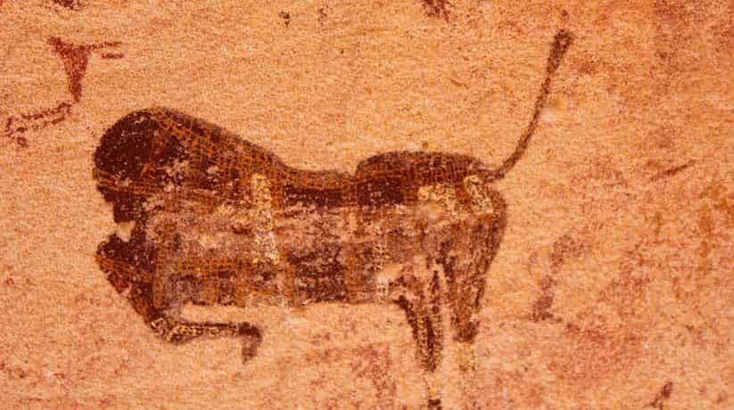
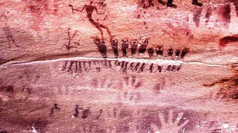
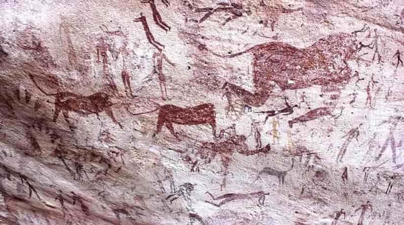
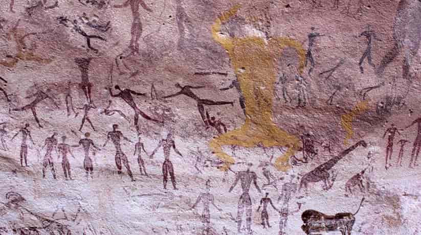
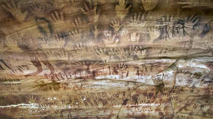
In fact, Karkur Talh valley, named after the acacia trees which still grow here. Moreover, the valley is the home to vast quantities of rock art- both drawings and engravings. Furthermore, the valley is definitely worth a visit. Though not as amazing as those of El Mestikawy Cave they extend over a much wider area. Guides will know the locations of the best rock art examples. Actually, you may, in the side Wadis (Valleys), even find some new examples of your own.

Nearby attractions Information, tours and Online Booking

More of Egypt Deserts and Oases

More of Egypt attractions

MORE
El Mestikawy Cave Egypt

El Mestikawy Cave Egypt

  • El Mestikawy Cave Egypt
  • El Mestikawy Cave Egypt
  • El Mestikawy Cave Egypt
  • El Mestikawy Cave Egypt
  • El Mestikawy Cave Egypt

El Mestikawy Cave Egypt tours, booking, prices, reviews

El Mestikawy Cave Egypt is a famous site because of its prehistoric rock art. In fact, it also called Cave of Beasts or Beasts Cave. The cave located near Gilf El Kebir in Western Desert, Egypt. The cave features similar art to the Swimmers Cave and Shaw’s Cave. In fact, the last two cave also located in Gilf El Kebir. The cave discovered in 1922. Moreover, it is larger than Swimmers cave and Shaw’s cave. Furthermore, it has a lot more rock artwork and engravings. In fact, the cave has variations in color as well as subjects. Moreover, it also has some arts which painted over. the arts show a sustained and prolonged habitation of the area.

Further details about El Mestikawy Cave Egypt:

The cave indeed is remarkable site. The cave features hand print drawings which done over a half buried. Furthermore, the wall also has paintings of human figures and animals. Moreover, the wall also features representations of hunting activities. There’s also an impressive drawing of a headless bull which drawn in several parts of the cave. Please do not touch the paintings or use flash when you take pictures. It is because the ancient paint will peel off.

Nearby attractions Information, tours and Online Booking

More of Egypt Deserts and Oases

More of Egypt attractions

MORE
Montaza Maamoura Archaeological Sites

Montaza Maamoura Archaeological Sites

  • Montaza Maamoura Archaeological Sites
  • Montaza Maamoura Archaeological Sites
  • Montaza Maamoura Archaeological Sites
  • Montaza Maamoura Archaeological Sites
  • Montaza Maamoura Archaeological Sites
  • Montaza Maamoura Archaeological Sites

Montaza Maamoura Archaeological Sites Egypt tours, booking, prices

Montaza Maamoura Archaeological sites are in a small bay in the eastern part of Alexandria, Egypt. They overlooked by Montaza Complex. In fact the archaeological sites are a testimony to the evident marine activity. The evident marine activity took place in the region in the period between the 1st and 6th centuries. Taposiris Parva, or the “Small Temple of Osiris” stood once on the small island. The island overlooks the bay from the east. The temple demolished in the 5th century. It was when Christians decided to destroy pagan temples throughout Alexandria. Moreover, the temple also known for its pagan High Priestess, Hypatia of Alexandria and daughter of Theon.

The Geometer who was the last head of the Great Alexandria Library before its destruction. This extraordinary historical figure known to be a talented mathematician, astronomer and philosopher. She shared her knowledge with her followers at the temple. She incurred the wrath of the church, which considered her acts as going against Christian beliefs. In March 416, Hypatia of Alexandria apprehended and beaten, before dragged into a church. Her abductors scraped her skin off with oyster shells or tiles. She believed that buried in an area known then as Cinaron.

Further details about Montaza Maamoura Archaeological sites:

There are no remnants of Taposiris Parva on the island, nor in the waters. The main attraction of the site is a long (approx. 200 m) stone pier dating back to the 1st century. It lies in 3 to 6 meters of water, surrounded by pieces of amphorae and small anchors. Maamoura Archaeological site located more to the east of Montaza. There lie the remnants of another stone pier, dating to approximately the same period. The area, some 6 meters deep also littered with pieces of amphorae and anchors.

A few years ago, one could also see bronze naval artifacts. Montaza Maamoura Archaeological sites can accessed from shore. You will need to make a somewhat long swim to reach them. Boats are also available for rent. The staff at the water sports center located in Montaza. The staff will be happy to help you out and guide you through your dive.

Nearby attractions Information, tours and Online Booking

More of Egypt diving

More of Egypt attractions

MORE
Regenfeld Gilf El Kebir

Regenfeld Gilf El Kebir

  • Regenfeld Gilf El Kebir
  • Regenfeld Gilf El Kebir
  • Regenfeld Gilf El Kebir
  • Regenfeld Gilf El Kebir

Regenfeld Gilf El Kebir Egypt tours, prices, booking, reviews

Regenfeld Gilf El Kebir was a storage place of the Rohlfsschen expedition in Dakhla Oasis, Egypt. Moreover, the site is an archaeological site located in Gilf Kebir, Egypt. If you reached one day this area, you shouldn’t miss a chance to visit Regenfeld. In fact, the site features a flat topped plateau. The plateau crosses several deep Valleys and towering dunes.

Further details about Regenfeld Gilf El Kebir:

Moreover, Regenfeld is the site where rainfall saved the life of Gerhard Rohlfs. It was during his exploration of the desert in 1874. Over there, you can still find the cairn Rohlfs which used to mark the area. Furthermore, there’s also a marble tablet which set up since 1933. In fact, it set up by Almasy. He was a Hungarian explorer. In fact, he depicted in The English Patient, in honor of the Egyptian explorer, Prince Kamal el Din. Finally, Regengeld is an Arabic word means Rain Filed.

Nearby attractions Information, tours and Online Booking

More of Egypt Deserts and Oases

More of Egypt attractions

MORE
error: Copyright © www.etltravel.com !